Pages

Thursday 22 July 2010

Day 9: Burnham Deepdale to Hunstanton

Last day of the walk, Burnham Deepdale to Hunstanton, the end of the trail. Up with the lark (or should I say the pigeon - God they are so loud!) at 4.45 am. I make a brew and eat a bread roll and butter for breakfast and I bin the almost empty gas canister that I won’t need again. I put fresh plasters on my somewhat blistered feet and at 6 am I am on my way, wanting to do as much of the remaining 12 ½ mile walk before the noon-day sun bears down.

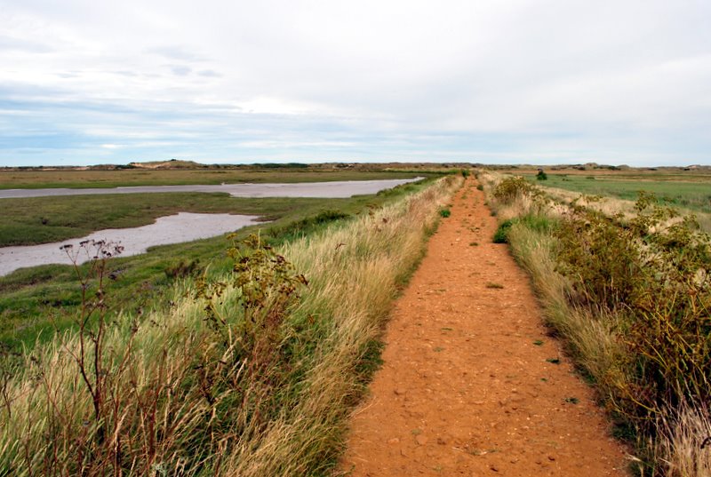
 As I set out on the path along the saltmarshes of the Manor of Brancaster my body casts a long shadow in front me, with the bright sun shining low on the eastern horizon directly behind me. I march for half an hour by the empty boats and lobster pots till I come to Brancaster Staithe’s small harbour, with shabby worksheds and a café that offers fresh fish and lobster all closed up at this early hour. It is a brilliant sunny morning with cloudless blue skies. The path goes on along the marsh, and on the left I come to the earthworks of the Branodunum Roman Fort, a 3rd century settlement that was used to protect and control shipping around the coast. How different the coastline must have appeared then. This path would have been the sea shore, not half a mile inland by a marsh.

Reed stack


Further on reedbeds dominate the marsh. In the winter months (December - April) the common reed is still cut for thatch and other purposes. Modern methods favour a mower like machine over the traditional scythe. The reeds are then bundled and stacked under tarpaulins. Cutters combine reed cutting with other self employed activities like woodworking and agronomy to provide year round employment. The cutter’s employment is threatened by cheaper reeds coming in from Asia, Eastern Europe and Africa. 80% of the reed used for thatching in this country comes from abroad. The North Norfolk Reed Cutters Association is looking into new uses for their product, like fencing. http://norfolkreed.co.uk


The path points inland and I find myself in Brancaster village proper. The place has been nicknamed Chelsea-on-Sea because of the influx of wealthy 2nd homebuyers in recent times. I’m told that at weekends the fancy pedigree dogs on parade make it more like Crufts-on-Sea. With not a soul about at 7.30 in the morning I am spared an opportunity to be irritated by the Henries and Virginias of Brancaster.


Going east along the A149 a small arrow on a telegraph pole points inland, but I am not sure this is for the coastal path or some other route, so I’m reluctant to wander from the road that points to Hunstanton. A tarmacced path along the road makes for easy walking in the sun. Coasthopper buses go by in both directions. I come toTitchwell, a village notable for a number of simple municipal looking red brick houses with green painted gables and privet hedges that I am quite taken with; a change from the usual flinty facades. An old fellow approaches carrying a big hedge trimmer and I ask him as he goes past if I’m near the coastal path. Without looking at me he pauses, breathes out, and says with great weariness “you’re orn it, you carn’t go alorng the beach”. Quite what can weary a man so much at 7.30 in the morning I don‘t know. Getting up, I suppose.

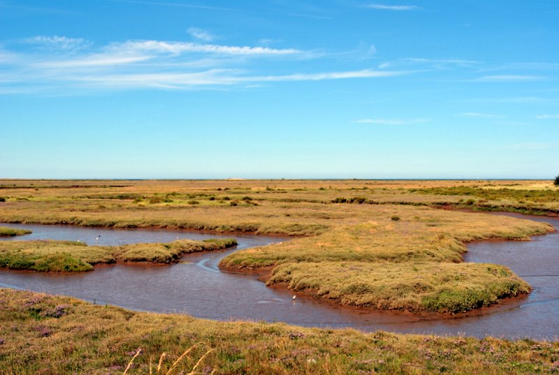
On the right seaward side there are wheat fields and a saltmarsh nature reserve that I have seen signposted. Then I come to Thornham. Their folksy village sign on the green depicts a blacksmith in his forge, hammer raised over an anvil. I make my first stop of the day on a shaded bench, have some water and fruit pastilles, and catch the waft of toast on the breeze from a nearby kitchen.


Heading for Hunstanton
A bit further down by the bus stop an acorn sign points me back towards the coast, and I learn that I have missed a bit of the coastal path that went inland – there’s no going back now. Over a wooden bridge over a ditch I cross reedbeds by a red gravelly path. Then it’s left and up on a sea defence getting closer to the sea. With the beach approaching, signs warn of the danger of being caught on raised sandflats as the tide comes in. I hit a long sea defence path that stretches out almost as far as you can see, running parallel to the coast. On my left there is an enormous stack of reeds. Eventually the path bears right and a beautiful small lake emerges, again surrounded by reeds. Here is located Holme Bird Observatory, and I take a second stop at a sheltered bench.


Going on I enjoy the shade of pine trees that grow alongside the nearby dunes. A sign points to the Holme Nature Reserve Visitor Centre, but it doesn’t open for half an hour, and I press on, sensing that I am making strong progress along the final stage of my walk, and not wishing to resist my desire to make the finishing line in good time. I still stop and look regularly though, and take photographs, sometimes walking back little ways to get desired shots, as I have done along the whole walk. My camera now carries a precious digital cargo of 1163 images collected since my departure at Stratford eight days ago.


Near Holme


The path takes me to the top of the dunes for a fresh view of the beach and sea. The dunes are separated off from the beach by a meandering wooden staked fence. A passer by confirms that the white tower I can see on the cliff on the horizon is the old lighthouse at Hunstanton. It is only about two or so miles off, and I feel a rising elation at being so near to the end of my journey. I bash on with renewed energy, and soon come to the signpost marking the beginning of the Peddars Way. This path starts 47 miles inland at Knettishall Heath, follows an ancient roman road for much of the way, and joins the North Norfolk Coastal path at this very point.


My pace slows considerably as the path turns to soft sand between the Hunstanton Golf Club course and the Old Hunstanton beach. With over an hour till noon though there is no need for unnecessary toil, and I relax on the porch of a shuttered beach hut and shoot the breeze, in a solitary, silent, satisfied kind of way.


I climb over the dunes and out onto the flat sands of the beach, where a smattering of holidaymakers are enjoying the sunshine. The tide, as always it seems, is out, out, out. I had anticipated I would take a celebratory dip when reaching Hunstanton beach, but again my simple minded desire to reach the finish of the walk overrides this more edifying option. I climb up to where the path continues on the rising cliff going up to the old lighthouse. Past the lighthouse the cliff bends round and a seagull glides past. Warning signs behind the cliff fence, sun bleached Samaritans posters (“need someone to talk to?”) and one makeshift memorial cross marked “Ritchie” tells me that some who have passed this way have made it their life’s last step.


As the grassy cliff top curves further round I see the great expanse of The Wash ahead of me, and the far Lincolnshire coast. Then down a little way by a seaside café I stop by the sign marking the end (or, coming from the other direction, the beginning) of the path. I get my camera out to snap a celebratory picture of myself and I’m quickly offered assistance with this by an elderly group leaving the café. I chat to them a bit about my walk, and accept a bit of congratulation. One comments on his inability to walk much at all these days, and I acknowledge my own good health and good fortune, a few blisters and insect bites notwithstanding.


So I have completed my mission. Hardly conquering the north face of the Eiger I know. The weather has been enormously kind, and the flat terrain is easy meat for walkers; nevertheless I allow myself some satisfaction at completing the journey, as I certainly did while on it. I took nine days when I could have taken four, but the trip was all the better for that, I’d say. Hunstanton looks a nice seaside town, but the walk done I can’t muster interest or energy to explore or appreciate it – it feels academic now – Hunstanton will have to keep for another day. Within an hour I am on a bus to Kings Lynn, and then on the train to Kings Cross Station and home. I’ll definitely do another walk some time, maybe a bit more ambitious, maybe a little hillier? Or maybe I’ll do the Weavers Way going south from Cromer, down to Lowestoft and wild camping on the Suffolk Coast? Maybe next time it will rain? Next time I may even bring a map.
Hunstanton


Wednesday 21 July 2010

Day 8: Burnham villages

A day with no plan. After a breakfast of bacon and crusty rolls I head across the road to St Mary’s church, with its distinctive round Saxon tower. After having a look inside I go into the churchyard to shelter from the sun and write till noon.


I decide to wander inland to look at the Burnham villages. Map from the information centre in hand, I follow a path that goes along the hedge of a wheat field by the road. I love to see a strong successful field of waving golden corn at the height of summer. I break off a tiny ear, rub it between my fingers, and when the little germ comes out, I put it between my teeth and bite into it.
Burnham Deepdale


Further on, I come to a bit of farming activity. On the edge of a potato field, a lorry is tipping its load of big red potatoes onto a stepped conveyor belt where two lads wait at the bottom, tossing any odd bad’uns away. The spuds then drop into the next section of the machine, where they are washed and come out the other end clean and ready for the supermarket. A big truck is also there, waiting for a full load to accumulate.


The path goes left through the welcome shade of trees and then right down a hill to the village of Burnham Market. Numerous shops and cafes, some shabby, some upmarket and smart, are on both sides of broadway with a small green and an island of trees in the middle. The big town sign on the green depicts a mediaeval market scene. I walk once round to find the best tea and savoury pie on offer. There are lots of people about; cars are parked in most available spaces, and this despite some places closed for lunch, and some even closed for the day, in dogged observance of Wednesday early closing. I get tea and a sausage roll at the bakers where I also get muddled directions to Burnham Thorpe from an agreeably flirty young assistant. Her “well spoken” accent tells me she won’t be working as a bakery assistant for very long.


After eating I wander on in the hope of getting to Nelson’s birthplace, but I end up in Burnham Overy Town, not Thorpe. Unconcerned in the beautiful sunshine I admire the Norfolk lavender and hollyhocks outside pretty stone cottages. The church offers a me a good shelter from the sun. A little note on the door of St. Clements Burnham Overy reads:


“We ask that this door be always shut, lest a bird enter and die of hunger and thirst”.
St Clements Burnham Overy

Inside the empty church is welcomingly cool, and I sit at a pew. A bible and prayer book lie open on the lectern in front of me. On the wall above the pulpit, impressively rendered on four stone tablets and dated 1747, are three stern quotations from The Bible: The Ten Commandments, The Apostle’s Creed and The Lords Prayer. I note the similarity of the inscriptions to the 18th Century gravestones I was encouraged to admire in Weybourne. Both highly crafted and yet seemingly haphazard, words are carried on to the line below if they exceed space and can’t be completed, or they are overwritten in small letters above the line, where mistakes appear to have been made. At rest I read each inscription, noting the archaic variations of the text from those familiar now:


“From thence he fhall come to judge the quick and the dead. I believe in the Holy Ghoft; the holy Catholick Church; the communion of Saints; the forgivenefs of fins…”


Two women rattle with the door and enter the church, stay a while, and then go, carelessly imperilling the birds by leaving the door open. May God show mercy on their fins.


Remembering that Google Maps on my phone sometimes works, I try it for directions to Burnham Thorpe. The app dutifully pinpoints my exact location and indicates Nelson’s birthplace down the road a way. I’m drawn off the road by a footpath that appears to be going the right direction but isn’t on the radar, and end up going somewhat back towards Burnham Market. Unconcerned I’m tempted by a children’s rope swing over a gurgling stream, but as the rope creaks and the log swing gives under it’s 15 stone load I think better of it. On I walk, jumping once at the sound of a nearby shotgun going off.


Back on the road I get to the sign “Burnham Thorpe - Nelson’s Village”. The place is quiet and still in the heat, almost oppressively so. In Nelson’s time, you imagine a village like this would have been quiet, but nevertheless lively with rural human activity. Not now.


Looking for something to mark the origins of the Lord Admiral, I aim again for the church. To visit a third church in one day is going it a bit for this heathen, but I reason my mission warrants it. My ignorance of the nation’s naval hero greatly exceeds my knowledge and my personal feelings about him are vague and ill formed; neither strongly positive nor otherwise. Nevertheless as I pass through the shade of the trees in the summer stillness by the church gate, I have a feeling that I am going somewhere important.
All Saints Burnham Thorpe


Inside the church of All Saints, Burnham Thorpe, I do indeed find a shrine to Horatio Nelson, which I might have realised had I known that he was the son of the Reverend Edmund Wilson, once of this very parish. Entering I see a huge Royal Ensign of the type flown on ships in Nelson’s day. I look at a copy of Nelson’s birth certificate on the wall, read the prayer he composed for his seamen on the eve of the Battle of Trafalgar, and pocket a picture postcard of his birthplace, the Old Rectory, Burnham Thorpe. Then I stop by a large display, made up of eight cardboard panels, pull up a chair, and begin to read the story…


I shall not trouble you with a retelling of the story that is told so splendidly and clearly in words and pictures on those eight panels. But I can say that I was very impressed and affected by what I read. He was bold and audacious in battle, leading his men into defeat as well as victory in a remarkable catalogue of campaigns, during which he successively lost the use of his eye, one arm and ultimately his life; this is well known. Other details about him, of greater or smaller significance perhaps, impressed me equally: his early experience at sea from the age of 12 where he formed a bond with the ordinary seaman and a horror of the tyranny of the Royal Navy; his petitioning for improved pay and condition for Norfolk farm labourers; his poor and hazardous shooting skills; his furious digging in his garden, while waiting for his naval commission, “as it were for the purpose of being wearied”; his willingness to ignore or defy orders in battle if he thought the situation demanded it; his evident personal charm, persuading William Hamilton to allow him to live under his roof, despite being his wife Emma’s concubine and the father of her child; and finally, the convulsion of national mourning after his death, that completely eclipsed any celebrations of victory over the French led invaders.

To quote the display, Nelson was “all things to all men: fearless but vulnerable; vain but insecure, morally upright yet flawed; ruthless yet humane; classless but ambitious; both superman and everyman”. What no end of words can do adequately, is communicate the unique and powerful qualities he must have possessed to inspire, persuade and lead those around him to victory against his many and more numerous adversaries. And despite disputation (we know the stories we are told are not all true, may be flim-flam, hog wash, and will be constantly revised) history is, logically, and like Burnham Thorpe, a settled thing. There is no other outcome; Nelson prevailed, and it is impossible to imagine what kind of country we’d be living in now, if he had not.


Tuesday 20 July 2010

Day 7: Wells-next-the-Sea to Burnham Deepdale

By 7.45 am I have had a cup of tea, forced down a second bowl of porridge (which I always find almost impossible, like eating three cream crackers in a minute) packed and I’m ready to go. In the lounge I meet the Northern Lass from yesterday, who is similarly all packed up and ready for action. She’s heading for a B&B in Brancaster, the next village beyond my destination of Burnham Deepdale. Checking I have a full bottle of water, I say goodbye to Wells YHA and stride ahead down the lanes towards the harbour, stopping for energy giving wine gums at the newsagent. An Eastern Daily Press board outside says “NORTH NORFOLK AUTHOR DIES”; I wonder who it is but don’t stop to find out.


The weather is pleasantly overcast, but my presumption (which proves false) is it will clear and get hot. Rounding the harbour, where four big fish (cod?) bask in the shallows in a place I had seen them last night, I head towards the beach along a long straight path with a muddy inlet and beached boats to my right. It may be Wells-next-the-Sea but it’s well over half a mile to get there. Near by the beach there is a huge vessel moored that looks partly like a dredger and partly like a road excavator. It’s being used to clear a channel to allow construction vessels out of the harbour to get to the Sheringham Shoal Offshore Wind Farm, which I have noticed from time to time, far, far out to sea, sails turning and glistening in the varying wind and light, like a mirage.


I stop to read the information board. I find it hard to imagine how the free energy eventually earned by such a project can repay the huge investment required to construct and maintain it, especially as the turbines are so far out to sea. Of course I am in no position to calculate this, but I wonder if, as with nuclear power projects before like Bradwell and Sizewell A down the coast, those involved in building these great projects are really interested in making that calculation, or indeed in the end if they even know how to make it. The assumption with wind farms is that unlike nuclear reactors they harness an eternal resource, but I should think in reality these wind farms must have a shelf life too, needing to be knocked down and replaced one day.


Just before the beach, signs pointing to the left are a bit unclear. I walk over the dune to find the beach, Wells’ famous beach huts (which trump in number and variety those seen in Sheringham) line up in front of an evergreen wood, and the flat sands of the huge beach stretch out at low tide. I ask an elderly lady with a dog where the coastal path is, and she suggests if I’m going west just to walk across the beach towards Holkham. This sounds good advice, and I make for where the sand is wetter and firmer underfoot, and strike forward through a few early morning dog walkers, with the beach huts and pine trees to my left, and the shore still far out to the right. With the weather still overcast and the sands offering a likely shortcut, my confidence rises that today’s stage will be easily achieved. After a while I find myself the only walker out. A distant crouching black figure standing oddly on the edge of the shoreline proves to be a cormorant, wings half extended like a bat. A primeval predator pondering a paddle? As I get nearer it lifts itself off the ground and flies low along the shore, before rising and wheeling inland.
Holkham Beach


Two swimmers emerge and I ask the ladies for directions. Holkham is already passed, but I can get back on to the path about three quarters of the way along the dunes as we look at them. Further up, the next man I see says there’s a path through the dunes a quarter of a mile along, marked with a sign. Trouble is, on the open flat sand it is hard to know how far you have been and how far you have to go. I don’t want to walk near the dunes because the soft dry sand is hopeless for walking under a heavy pack, so I walk further out on the firm sand, where spotting the path is more difficult. A couple of red billed oystercatchers forage on the sand, systematically walking away from me as I walk towards them. Eventually I come to a fenced off bit of beach where a bird watcher tells me I’ve overshot by half a mile. It’s a dead end in front but I can walk across the dunes to a boardwalk path.
Towards Burnham Staithe


I walk across the grassy, mossy top of the dunes (peppered with millions of rabbit droppings) till I hit the board leading to a path going inland. Looking quickly around, panic stricken rabbits dash for their holes. Ahead, as I walk along a gravelly sea wall, surrounded by salt marsh, my destination marked by a windmill, lies Burnham Staithe. The approach reminds me of the one to Cley – sea wall, saltmarshes, windmill and all. Delightful as it is the North Norfolk Coastal Path is not one of constant novelty.


Burnham Overy Staithe is one of 6 Burnhams in the area, the others being: Burnham Overy Town, Burnham Thorpe (Nelson’s birthplace), Burnham Market, Burnham Norton, and Burnham Deepdale. Staithe is an old Middle English word for loading wharf. The town thrived from the middle ages onward as a small port serving the local area, but like neighbouring places now struggles to hang on to a route to the sea. It claims to be where young Horace Nelson (later to be better known by his full name Horatio) is likely to have had his first taste of sailing. After walking right through the village, I find that the chandlery on the harbour that I had walked past is the place for teas and coffee, and I go back to rest up and eat my pork pie, while kids with posh parents play on the quay. Half way into my pie the Northern Lass strides up out of right field. Clearly my short cut across the sands hasn’t stopped her from catching me up, despite a head start. We share a bench and a bit of a chat, then I let her go on ahead while I get a second cup of tea. With the day still overcast and half today’s route already completed I know I am going to make this stage of the walk with ease.


The path continues along the road out of the village and then turns off to the right near the windmill across a field where cabbage white butterflies riot over a failing crop of lettuce. Then it’s up onto another sea defence wall that heads out seawards over channels and sluices and then bends to the left between pasture (inland) and a narrow stretch of mud and water before dunes to the coastward side. There are a few walkers about and I ask a couple of them to take my picture; always a good ruse to get a bit of chat going. Most prove to be campers at the Deepdale site I’m heading for. The path, lined with long grass and wild plants and flowers, goes on straight for a mile or so. The weather is set pleasant warm and overcast for the day, and I slacken my step a little, stopping twice, to take it all in. Eventually the path turns inland towards trees and houses and ends by a beached narrow boat that sits on the edge of the vast salt marshes of the Manor of Brancaster. Down a road and through some trees I find myself at my campsite, and it’s only two o’clock.


The Deepdale campsite is located behind a newly built precinct of small shops, a café, a Costcutter mini-supermarket and a Murco (who?) petrol station. It’s part of a complex that includes hostel accommodation, an information centre, and a fully working farm. A wall boasts various award plaques for Deepdale Farms, including an “Investors in People” award, the scheme supported by the government to promote good employment practices. It certainly seems a popular place to work; numerous young Deepdale employees are about, all wearing their light blue Deepdale polo shirts, and I’m amused to see they are not appearing to be overly exerting themselves. Maybe it is the time of day. One ineffectively shoos a swallow from under a semi enclosed roof, another two idle and canoodle by the laundry, where my clothes are getting a desperately needed wash. To be fair to the staff, my numerous visits to the information centre near where I’m pitched are unerringly dealt with helpfully and patiently, as I return repeatedly, Colombo like, with additional requests for information and help, planning now my next moves and eventual journey home. Liking the place well enough I decide to book my pitch for another night, leaving me one long walk to complete the coastal path at Hunstanton on Thursday.


I laze away the afternoon on the mat outside my tent, feasting on raspberries, bananas, cream, beer and the last of my samphire. The man in the big blue tent to my right, camping with his wife and their dog, comes over and chats to me at length. Ray’s his name, and he comments on the smallness of my tent and wonders how the young French couple camping to my left manage to squeeze into their own small shelter. I say I reckon that they manage well enough. Clearly this tanned, attractive pair is drawing the attention of fellow campers, and eyebrows are raised when they form themselves into difficult looking tantric yoga formations for implausibly long periods out on the grass, demonstrating their ability to squeeze into unlikely positions together.


A bit woozy from two bottles of ale already drunk, I wander to the White Horse Inn where as expected I again run into Ray and Mrs Ray who had left a while ago to go and eat there. Ray insists on getting me a drink even though Mrs Ray says they can’t stay for another “because of the dog”. The Brancaster Best is mighty fine, and when they’ve gone I take it to the veranda at the back and watch the sun going down over the saltmarshes.
Burnham Deepdale - 9 pm


Monday 19 July 2010

Day 6: Stiffkey to Wells-next-the-Sea

At about seven am I am up and marshes bound, small scissors in hand, to harvest samphire, the edible plants that grow in endless abundance on the marshes. I had seen some impressively large ripe stalks the day before alongside the coastal path, and I don’t have to go far to find plenty of the stuff a few yards along, and in a quarter of an hour I have a good handful. Back at the camp I fill a mess tin ¾ full, light the stove, put my inflatable mat around it as a windbreak and wait the long wait for it to boil. I cross my fingers that the dwindling gas supply won‘t expire at this important moment. When the bubbles come I toss in the samphire, after first removing a cupful of water for tea. After a while the water begins to bubble and take on a green tint. I give it a few more minutes, then switch off and strain.
Samphire

This stuff is sold as a delicacy in local restaurants, garnished with a little butter and lemon, for £4.95 a go. With a cadged knob of butter from my neighbouring campers, I put the first stalk in my mouth and draw it backwards through my front teeth, separating the succulent fresh from the very thin hard thread of the inner stem. Success! It is naturally salty, tender, juicy and pleasant tasting. The obvious comparison is asparagus (it is also called sea asparagus or sea pickle), but while asparagus is progressively tougher and stringier away from the tip, samphire is consistently good through the plant, with the exception of the inner string stem, a little pile of which is forming at my feet as I eat my unusual green breakfast. Accompanied by my sugary tea, the stuff gives the day a satisfying start.


The camp staff have warned me, apologetically, that I need to be off my pitch at the designated time of twelve because a group of local schoolchildren are arriving and need my space. As I once again begin the slow process of packing up my tent and kit, some people come and put up some wooden trestle tables and benches on the adjoining pitch, and these are soon followed by a procession of 6-8 year olds, who come down the slope in pairs singing “we’re all going on a Summer Holiday” in the morning sunshine. Song finished, the children and accompanying teachers and assistants start tucking into crisps and cans of fizzy drink. As I once again remove the yellow Day-Glo guy rope from my tent and start threading it through the loops of my shorts, two or three boys are distracted by my activity and stand gawping at me, shovelling crisps into their mouths, as I fasten my improvised belt into a bow at the front.


Today I am heading for the Youth Hostel in Wells-next-the-Sea, the only night on this trip when I’ll be sleeping under a roof. With the YHA not opening till five and the walk only 3 ½ miles I have time to kill, so I leave my pack in the campsite office at noon and head back into Stiffkey. At the village stores (an upmarket affair with a lot of gourmet food and a smart little coffee shop) I buy a pint of milk, a fruit yoghurt, a packet of caramel wafers and some sweets. These I take to the blacksmith’s bench by the bridge and scoff. Then up to the Old Red Lion where I make a pint of Nelson’s Revenge last two hours while I write up my notes. Disapprovingly I note a diner eating samphire, served with long roots clearly attached.


On the wall near the kitchens I see a full page cutting from the Daily Telegraph, a reprinting in 1995 of an original article in 1932, that reminds me of Stiffkey’s most infamous former resident (to be fair, probably its only infamous former resident). In 1932 Harold Davidson, the Rector of Stiffkey, was found guilty in a Church Disciplinary Trial on 5 counts of immorality and defrocked. For years Davidson had travelled each week to London on Monday mornings, usually returning to his wife and children late on Saturday in readiness for Sunday services. His mission in London was to assist and minster to poor and vulnerable young women in the capital; he would, for instance, frequent Lyons Tea House on the Strand, where the lowly paid girls employed there were easily led into vice and prostitution. Suspicions arose that Davidson’s interest in the girls was carnal rather than pastoral, and the resulting trial and scandal became a national sensation. Davidson became known as “The Prostitutes Padre”, and press stories claimed he had had immoral liaisons with over a thousand young women. The truth of the accusations against Davidson has long since been disputed. Was he really the world’s naughtiest vicar? Or was he guilty only of too much naïve Christian charity? It is hard now to know. What is known is that deprived of his livelihood and in disgrace, the former Rector of Stiffkey brazened out the remainder of his days living in a barrel and working as a lion tamer at seaside sideshows in Blackpool and Skegness. Here his singular and tragic life came to a predictable and poignant end, mauled to death by a lion like so many of his early Christian brethren.


Harold Davidson - "The Prostitute's Padre"
The coastal path begins by the gate of the campsite and I head along the sea wall defence; rich arable land (wheat, lettuces) to my left inland, salt marshes and sea on the other side. A sign tells me I am in Holkham (Stiffkey) National Nature Reserve. The sun is shining hot and strong. Ahead I see a young woman with a red t-shirt, shorts and a rucksack as big as mine, sheltering from the sun in the shade of a hedge. She's a northern lass, a fair bit younger than me, and I stop for a minute and pass the time of day before walking on. A while later, my rucksack straps sweaty and straining in the heat, I too decide to stop and sit by a similar hedge, and exchange greetings once again with the Northern Lass as she comes tramping past. She is only the third proper hiker I have seen this trip.

Between Stiffkey and Wells-next-the-Sea
As a channel of water widens on my right, the town of Wells-next-the-Sea emerges ahead. A little grid I have brought with me shows the distances and estimated walk times between places on the coastal path, and it is proving to be reliably and surprisingly accurate; I have made this stage within two hours, even with stops and hot sunshine, as the grid predicted. With still an hour before YHA opening time, I walk through Wells’ quirky lanes of shops. Not able to add anything of any weight to my overstuffed pack, shopping is of little interest to me, but I do stop at a butchers, which has an attractive display of pies of pasties in the window; necessary fuel for tomorrow’s long walk. With the senior butcher surprisingly unable to tell me if the Cornish pasties are beef or lamb (it has to be lamb, surely!)I play safe and go for a pork pie*. At 4.30 the pub near the hostel is closed, so I sit in the churchyard opposite for half an hour, resisting the temptation of the pie.


I’ve never stayed in a youth hostel before, at least not in a shared dorm. I check in on the stroke of five and stake my claim to one of the bottom bunks in a four bed dormitory. I had chosen the YHA partly for lack of a nearby camping alternative, but also because I thought it wise to have at least one night of relative comfort, in a proper bed, somewhere along my route. Now here, I admit to myself to being apprehensive about sharing this small stuffy room with up to THREE STRANGE MEN! Aware too that I might prove an unpleasant sweaty presence for my fellow boarders, I shower twice (excellent showers) and do my best to rinse both my pairs of socks, which on arrival in the room I had noticed were really humming.


I look around the shared areas of the hostel downstairs. It’s all neat and clean and homely, with rooms marked “Dining Room”, “TV Lounge”, “Quiet Room, Shhh…”, and lots of polite notices, especially in the kitchen, telling you what to do and where things are. In the dining room a couple of ladies finish their salad. In the kitchen, four glum looking men shuffle about making tea and washing up, and make no attempt at welcoming noises and avoid eye contact when I come in. I suppose they have been conveyed here by the community mini bus I saw parked outside. I realise that tonight at the YHA I will not perhaps be keeping company with many of life’s higher scorers; smart people have smart places to stay. I reign in my snobbish impulses by reminding myself that I am here not on some Orwellian mission to see how the poorer half live, I am here because it is what I can afford, given my own pinched circumstances. I can like it or lump it.
Wells-next-the-Sea


I collect my swimming shorts and sarong and head for fish and chips and maybe a swim. Unclear about where the beach is and deciding it is probably a bit of a walk I settle for the easily located fish and chips, which I eat on the harbour wall, as is traditional in Wells, watching marsh mud splattered cockney kids larking about and shouting in the shallow harbour water. Afterwards (for research purposes) I have a pint of Woodforde Wherry at the Bowling Green Inn near the hostel. The beer is good enough but again it’s mainly a dining establishment, and the lifeless lack of conversation in the beer garden tonight reminds me of my local Wetherspoons. Back at the YHA I am informed that I am the only one staying in my room tonight. I feel both relieved at not having to share and contrarily a little cheated at being deprived of the full YHA experience. Looking through the many maps and books at the hostel, I consider my route tomorrow. At eleven miles from Wells to Burnham Deepdale it is my longest stage so far, and I’m wondering if it might be a bit much if the hot weather persists. The chatty man on reception suggests wild camping on the dunes along the way.


Cup of tea in hand I retire early to bed to be in readiness for an early start tomorrow, but sleep comes hard. I’m informed it’s midnight by twelve slow chimes from the Victorian Church opposite the hostel. At one in the morning I am more briefly reminded of the time.


*I since stand corrected; cornish pasties are traditionally beef.

Sunday 18 July 2010

Day 5: Blakeney to Stiffkey

I wake up at 4.30 am, uncomfortable and a bit cold. It’s light and I decide to go for a dawn chorus walk over the nearby Blakeney Freshes. In terms of birdsong, the furious cooing of wood pigeons, especially from the town, overpowers everything else. With the orange/red sun half emerged over the horizon of the saltmarsh I discover samphire where the edges of the path gets muddy. These succulent green stalks are collected by locals who supply restaurants with them or sell them from wooden stalls around and about (“Samphire £1.50 a bunch – please put money in tin”). I try picking some but it’s difficult without uprooting them or crushing the fleshy stems. Having been told on an “edible wild plants walk” I had gone on in Kent that uprooting was not good practice and illegal, I decide to have a go at another spot when I have my scissors with me.

After porridge, raisins and a catch up kip I head off for a boat trip to see the seals at Blakeney Point - Blakeney’s big attraction. The trips don’t go from Blakeney Quay any more because the harbour is so silted up that you have to leave from nearby Morston Quay. The boat leaves at 10.30 am, but when I get there a little after 9.30 there is little sign of a rising tide. Sitting in the shade on a raised viewing platform I focus my eye on a fixed point in the mud and gradually the waterline reaches it and then submerges it. After a while I step down to join the growing throng of mums, dads, grandparents, and kids; there’s even a handful of Japanese tourists. Bean’s Boats run our trip and their people mill about with luminous orange jerkins with smiley seal faces on them. At last it’s 10.30 and we troop onto the boats - there are two each taking about 30 passengers.


We chug out and reach the open waters of the harbour, enclosed to the north by the long arm of Blakeney Spit. The many boats around us that seem doomed to spend most of their time mired in the mud are now bobbing happily on the sea as their makers intended. The other boat chugs ahead to the sandy tip of the spit while we hang back. I can just discern with the naked eye something dappled and bumpy looking disturbing the smooth line of the sand, which I think must be the seals. After five minutes the boat ahead moves along and it is our turn to home in, and gradually the shapes of 50 or so common and grey seal begin to clearly appear. Some lie still on the sand, some are looking at us, or at least towards us, with dog-like heads cocked quizzically. Some wriggle across the sand a little, like bound escapologists trying to slip from their bonds. They are large and impressive but clumsy and vulnerable looking. By contrast, a few heads emerge above and between the waves, appearling altogether more at ease and in their element.

 
The boat moves forward, turns round, and we are afforded another few minutes viewing. Everyone is snapping away taking pictures, or filming videos. I’m torn between doing the same and sitting back and taking in the encounter while it lasts, as our boat bobs quietly before these rare lumbering sea beasts. They are still a little distance and I know my camera’s 18-55 mm lens lacks to zoom to take the pictures I’d like to.Inevitably the boat moves on and begins to wheel round the point to the land facing side where the sand turns to shingle. The background sound of screeching sea birds increases, and within a minute we find ourselves in the midst of another natural marvel. The spit is home to a major colony of sandwich tern, who take advantage of this remote, fenced off strip of pebble beach to lay their camouflaged eggs in shallow scrapes, and there raise their young. The tern fly past us in furious activity, silvery fish in their beaks, delivering food to their speckled chicks, or plunging into the sea to catch the sand eel and whitebait that they feed on. The noise is terrific, and unprepared I struggle to capture the action with my camera - these elegant sea-swallows whizzing past and around us, with the seals loafing in the background. It really is a remarkable, contrasting scene.
Sandwich terns and seals at Blakeney Point

 
The excitement over, we stop for an hour a little way along the Point by the old lifeboat house, now an information centre since the old slipway got too clogged up with pebbles. I walk by the little huts on the dunes that are owned by Blakeney folk who may neither sell nor let them, then come out on the North Sea beach where fences and signs protecting the tern and seal from the destructive intrusion of man and his beasts warn you to walk no further,.


Back at Blakeney I ready to leave for my next stop at Stiffkey. It is only 5 miles along the coastal path. Walking the pleasant mile or so between Blakeney and Morston Quay a third time today irks me only a little bit. Coming out of Morston I see a couple of elderly samphire pickers and onwards from here I realise that the plant is to be found in vast quantities on the marshes, which are also peppered at this time of year with a pretty mauve coloured flower I don’t know the name of. The sun breaks through a gauze of cloud. I reach a place called Stiffkey Fen, and then signs indicate 1½ miles to Stiffkey, and the beginning of Stiffkey marshes, the biggest expanse of saltmarsh yet, which goes out and out till it reaches sand flats which in turn go out and out to the end of the horizon. Seeing a car park ahead and tents peeping through the trees to my left I know I have arrived at my destination.


The High Sand Creek Campsite is an old anti-aircraft training camp that sits next to the path and marshes and belongs to the local farm. A number of grey barrack like buildings remain on site and the lady in the wooden hutted office tells me that campers used to use the old military washing facilities until a new toilet and shower block was built 12 years ago. I check in and gratefully accept a pitch under a shady tree, along with the use of a plastic chair thoughtfully thrown in to augment my meagre camp comforts.


Around the campsite it’s a familiar scene; campers are soaking up the sunshine, relaxing at little tables and behind windbreaks with their bottles of wine, tending to barbecues, busying themselves with this or that. Many campers I have seen seem content to while away the day without going beyond the confines of their site. There is always some little job to do. For the most part, camping is the proximity of nature made tolerable by the rituals of domesticity. On a beautiful day like today though, nature needs little assistance.


At a little before 6 on this Sunday afternoon and in search of food and beer, I take a walk into the village, the hot sunshine seeming to accentuate the extraordinary quietness and stillness of the place. The Old Red Lion offers a cooling and pleasant pint of Woodforde’s Nelson’s Revenge, and I treat myself to a meal of sea bass and salad, along with another Pint of Nelson’s. The food is good, but as with most of the pubs I have come to on my journey, it caters mostly for diners and doesn’t offer much prospect of diverting bar room chat. (The exception to this generality was the Ship Inn in Weybourne, which had a public bar, a pool table and a handful of locals.

I wander down into the heart of the village, which is at the bottom of a valley in rolling green pasture. It is quieter than ever. Strangely someone has cut a hedge into the shape of an electric guitar. I stop at a grassy bank at an idyllic stone bridge by a shallow clear river, part shaded by trees. The silence is broken by the rude quacking of a female mallard that comes alongside me. Shortly afterwards she is joined by seven chicks and another mallard, and her quacking is calmed. I read the inscription on the bench by the bridge, dedicated to the village blacksmith who died in 1998.


“IN LOVING MEMORY OF WILLIAM (BILLY) GIDNEY
VILLAGE BLACKSMITH2.10.1901 - 8.4.1998"

Whether the situation he left vacant was ever filled I don‘t know.

Saturday 17 July 2010

Day 4: Blakeney

Around 7 am, outside the public loos that must serve me and my fellow campers as a washroom, I catch the smell of bacon coming from a van in the Blakeney Quay car park. Tempted, I go over and purchase a tea while considering the steep asking prices for a bacon bap. I’m asked by the swarthy old car park attendant, chatting to the van owner, if I’m camping in the field - something about my appearance has obviously made this evident to him. I chat and joke with him and the van owner about the campsite and ask if they know anything about the owner Mr. S, which they don’t. I decide a bacon bap is a necessity and sit down to share it with a friendly sparrow and a crow.


A kerfuffle breaks out by the car park hut, where a skin headed thug in shorts has got out of a white estate car and started threatening and pushing our friend the car park attendant. “Come on then. Come on then. Let’s do it now, let’s sort this out here and now” he’s shouting, squaring up and pushing our man disdainfully with his fingertips. The car park guy stands his ground and laughs it off as a bit of a joke; which it clearly isn’t. “He’s the local idiot”, says the breakfast van owner, perhaps to assure me that there’s only one. The confrontation fizzles out and car park man returns, “wasn’t going to let him provoke me at work,” he laughs. Fair play to him, he looks a tough enough old sort.
Blakeney Quay

With no plan for the day I walk around the town for a while, looking in the shops, looking at the boats for sale board. A shower of rain sends me and others running for shelter in the stone arched remains of Blakeney Guildhall. The Guildhall is a relic from long ago when this was a major sea port and trading post. Over the centuries Blakeney Spit, now a 9 mile shingle bank, has extended it’s long arm across the harbour, gradually cutting the port off from the sea, silting up most of the harbour and turning it into saltmarsh. Now only the smallest boats can thread their way along the ever narrowing inlet to the quayside, and then only during a few hours at high tide. Neighbouring Cley and Wiveton, themselves once significant ports, are completely cut off. Many harbour towns in East Anglia have suffered similar fates. Some, like Dunwich in Suffolk, have literally fallen into the sea. Blakeney and its neighbours has been cut off from it. Despite new activities like tourism that keep the town appearing prosperous, you can’t escape the feeling that Blakeney is a place that has, historically, had its day, and is doomed to be forever in want of its former purpose.


After lunching on milk, sweets and Norfolk strawberries I decide to head inland. Taking the road to nearby Langham I go left at the first country footpath, which turns off by an untidy holding of caravans, building works, kids play equipment and a net covered quail farm. All this is guarded by two large excitable dogs that bark at me furiously from behind a wire fence. The nervous quail live up to their name, drawing back in fear to the far side of their netted Stalag while I walk past.


After a half hour's walk through fields and hedges, with the sun warming up, I come to a place called Wiveton Downs, a designated Area of Special Scientific Interest. These “downs” sit on Blakeney Esker, a glacial formation consisting of five high ridges of sand and gravel deposited here by meltwater distributaries that ran at the bottom of the huge ice sheet that covered this area (and most of Norfolk) during the last ice age. In appearance it’s a parched looking, gorsy, undulating heathland, extensively sculpted with rabbit burrows, that offer raised views of the imposing St. Nicholas Church tower rising above the trees, and the sea beyond. The terrain is similar to Beacon Hill visited a couple of days ago, which is also an ice age formation. Again I hope to see a snake, without expectation. For Centuries Wiveton Downs were heavily quarried for sand and gravel, until all the useful stuff had gone around 1880. Today the vegetation is managed to encourage the kinds of plants that thrive on the esker’s well drained sandy acidic soil, which provides an ideal habitat for linnet, woodcock, short eared owl, and yellow hammer. I know all this because I read it all on one of the permanent illustrated information boards and wrote it down. This is also where I learned that the cliff-hillock over Sheringham is Beeston Bump – a hump of sand and gravel formed when all the surrounding rock eroded away. Why the rest was eroded while Beeston Bump remained is not explained; there is only so much these informative boards can tell you.


Sitting on the highest point of Wiveton Downs as the afternoon gets later, with my mobile phone battery dead, I reflect on the advantages of being along on my trip. My time is entirely my own and does not need to be negotiated with another. I can walk at my own pace, stop, sit, even read information boards, something you never feel easily able to do, say, with your kid in tow. Eventually I get down from my elevated perch and head down the single track country road that heads back to town. There is no traffic about, the sun is shining, and the only thing to be heard is the breeze blowing through the hedges and the occasional “pop, pop” of a very distant shotgun. I kick a stone down the middle of the road for a while and congratulate myself on what a good combination of idleness and endeavour my trip is becoming.


What's on in Blakeney
In the evening I stew up some instant noodles and mushrooms and head to the local British Legion where a Neil Young tribute band “Don’t Spook the Horse” render Harvest Moon and Old Man more than competently. I peer in to the fairly packed hall but am content to listen outside with a pint and a smoke while my batteries charge by the bar.

Friday 16 July 2010

Day 3: Weybourne to Blakeney

I’m excited about going to Blakeney. Memories of going out on boat trips around the Blakeney Nature Reserve when I was a little boy have endured strongly, and I have long wanted to revisit the place. In the morning I perform again my careful and fastidious packing routine, but this time I opt for belt free long cord trousers so the guy rope can stay attached to the tent. My pack includes a needle, strong thread, a thimble and small scissors as a repair kit should one of the rather old and suspect straps break or tear. On close inspection though there doesn’t seem to be anything needing a stitch. With nobody else with me, my pack becomes something of a companion. I’m relying on it to get the things that I need to the places I want to go. There is a mutual dependence between myself and it:

Oh Pack I will look after thee
Wilt thou look after me?


Hungry and looking for a full breakfast I plan to go back into the village where I’d seen them on offer yesterday, but old Wharton advises me that “there’s a caffy in Keeling - it’s on your way”, so I avoid tracing my steps backwards through Weybourne and take this more progressive option. Unfortunately there is nothing much resembling a breakfast in the tea room cum bookshop and antique emporium in the next village of Keeling. I settle for an unsatisfactory microwaved sausage roll and ropey coffee.

Going back towards the path, I’m cheered by the warm bright sunshine, still prevailing despite the rain clouds crowding in. I take pictures of butterflies along the hedged path and decide to take a dip in the sea when I get to the next beach. The path leads out to the road and the road leads to Salthouse (named because it was a store house for salt, would you believe), then a road to the right leads to a high shelf of shingle beach. I scramble over and find a decent gap between the sea anglers on the shore (evidence of the deep water to be had here) where I wriggle into my swimming shorts and charge in. Fully immersed, I bob about, lie on my back and wriggle my tender toes about in the cold brine. A grey cloud goes in front of the sun as I lie looking up, and I follow its slow progress; when it finally moves past and the sun comes out again, I swim to the shore and scramble out to let the sun dry me off while I lunch on peanuts and raisins.


There is an absence of coastal path signs here, but I know that the path is supposed to follow the coastline until Cley (pronounced Clie) where the path works its way inland to the town. You need to avoid going beyond the turn off for Cley; if you continue straight past you will start along the 9 mile long Blakeney Spit, that continues to the fenced off dead end at Blakeney Point inhabited only by seal and tern colonies (a boat trip is planned for Sunday). Heading for the Cley turning, I opt to walk along the landward side of the path, where saltmarshes are beginning to stretch out on my left. At first the terrain alternates between easily tramped turf and toilsome pebbles, but as it goes on it gets less turfy and more pebbly, as the encroaching stones bury the last semblance of path, along perhaps with the original signposts.
Avocet
Salthouse to Cley
Walking through one of the many shallow pebbly pools I disturb a sole avocet, which I manage to photograph as it rises and flies off. Further on to the left there’s a lake shaped like a fat horseshoe, with unidentifiable geese on the ridge of land in the middle. Further on still a bigger, shallow looking expanse of water stretches out. The walk is generally deserted; just me and the birds for most of the time. A bird hide emerges overlooking another watery stretch. It’s a shame I don’t have binoculars, to be honest. I just couldn’t carry mine (which are old and heavy) and my camera. My eyesight is keen but so much is so far away.


Eventually I come to the Cley beach car park and there are clear signs for the Blakeney National Nature Reserve (ahead) and the North Norfolk Coastal Path going left (Cley-next-the-Sea 1m). From here it’s an easy flat walk along the path across the wetlands towards Cley’s windmill ahead. On the right of the path is a channel of water that separates the marshes on the Blakeney harbour side from the Spit. At just before 3 pm I treat myself to my first taste of draught Yetman’s Beer at the George in Cley. After today’s walk this superb ale is really something.


Blakeney is now only a mile away but the path wants to take me straight back out towards the sea alongside the channel and path that took me into Cley. Before that, still on the east side of the channel, I walk a concrete walled  path alongside which boats are moored (or abandoned) on a channel that is only a metre or two wide and surrounded by reeds. It’s through the town a bit and then I’m directed onto the long straight path along another raised sea defence towards the sea that lies obscured behind the horizon. After about a mile, near the shingle beach that can’t be seen, the widening channel turns left to follow the coast and the path goes with it. With time aplenty I stop twice for lengthy periods to take in the scene. On the muddy banks two shelduck with about 10 ducklings waddle along, following each other in and out of the water, and again in and out of the water, to no apparent purpose. An elegant white wading bird (a little egret) shows greater intent, steadily wading out along the shallow water, jabbing its bill into the mud with regular nods of its head. It then briefly takes to flight to peruse similar shallows a little further in front.


Blakeney
Gradually the road bends round to the left and the old town of Blakeney emerges; church tower rising from the trees above the town, yacht masts visible in the foreground. A fine John Deere tractor approaches me along the road that runs by the path to my left. A heron stands serenely in a pool in the sunshine; beyond the pool is a reed stack covered in a tarpaulin. As I get nearer the boats I hear the sound of rigging clapping against masts in the wind. The sound gets louder as I approach, as if applauding me for making it to the end of todays walk. I know, as if.


Now to find my campsite. I know it is a field opposite the Manor Hotel, and there is the Manor to my left at the end of the path. Opposite the Manor I find a gate and field that checks with the picture I’d seen on the internet when hunting North Norfolk campsites.


Booking this was an odd one. On Google it was the only campsite in or around Blakeney that I could find. The one online review called it “a charming new spot for nature lovers”. A single meadow with a cold water tap and public loos just down the road. Basic. The asking price was £20 per tent per night - too steep - but I’d rung the proprietor, a Mr S. and he was persuaded to give me the 2nd night I wanted for free, so at £10 a night this seemed fair to tolerable. I wired Mr S the money he wanted into his company bank account, and he confirmed by email with a booking number.


My booking number is 401A, and as I walk round this empty field, every square foot of which is covered with small but very prickly thistles, I wonder by what logic or random process that precise booking number was arrived at? Am I his 401st booking? This seems unlikely considering the field is empty on the weekend one week before the commencement of the school holidays. And what might the “A” represent? Despite the fine weather, closeness to Blakeney Quay and “proximity to nature” I can’t suppress a cheesed off feeling that somehow I’ve been taken, especially as I commence cutting a thistle free patch beside my tent with my little scissors, in the hope of preventing my inflatable mat from being punctured when I lay it there.


I wander to Blakeney Harbour and it’s a pretty picture; the inlet curves in along the quay, kids and mums and dad are occupied with crab fishing, the odd boat chugs in, signs advertise boat trips to see the seals, pretty flint buildings stand on the harbour front. I spot a couple of hikers, laden similarly to me an hour ago with tent equipment, stepping off the path, and I go over to chat to the elder while the other (his son) goes into a shop. I’m curious to know where they are camping. Getting slightly unforthcoming and grumpy responses, I become self conscious at being a stranger asking questions, so I make an excuse and go.


Feeling a little lonely, I ring up my daughter for a chat. Before leaving I had told her about the legend of Black Shuck, the mythic hound appropriated by Conan Doyle from the East Anglian coastline to Dartmoor in The Hound of the Baskervilles. Over the phone we laugh and howl in mimicry of the "Straunge and Terrible Wunder", also known as the Doom Dog, it’s eyes like saucers and as big as a horse, which terrifies and brings a curse upon those who encounter him. I joke that if I’m going to meet this fatal beast on my journey this will be the place.


At the end of my call, with the light becoming gloomy, I realise that no amount of jesting and bravado was going to shake off the feeling I had somehow formed that there was something remote and spooky about Blakeney, and I didn’t much fancy sleeping in the empty field owned by the mysterious Mr Wm S, here on the edge of the wild saltmarshes. I sink a couple of joyless pints at the Kings Head, where I come across the two grumpy hikers again (who avoid talking to me) and then return to my tent before it’s completely dark. There I lie, with eyes shut, jumping a little at innocuous noises outside the tent. Eventually I am put out of my misery; at half past ten a car illuminates the dark field with its headlights, and a family of four get out, girls ooching and ouching on the thistles as they leave their car in bare feet. I get out of my tent, have a beer and a smoke, chill out and go to sleep.

Thursday 15 July 2010

Day 2: East Runton to Weybourne

Sleep in my coffin shaped tent is patchy, it‘s like the undertaker measured me up wrong. I am not a fussy camper and usually sleep like Homer Simpson as long as I’ve got something over the top of me and a dry arse. The problem is it’s just that bit too short; either my feet are rubbing at the end or my head is constricted at the top. In the end the semi-foetal position seems best, though this is tricky in a sleeping bag. At least the self inflating mat I have invested in works OK, and in the morning I find it makes a good makeshift windbreak for my camping gas stove, which is useless without it.


I am up at 7. It rained a bit in the night, and the forecast for today is rain on and off. I get myself a shower (excellent facilities in Woodhill Park - award winning!), make a brew, and then start the slow, incremental process of packing up the tent, clothes and kit. Of necessity camping makes you patient and methodical even if usually you are neither. There may even be a Zen like happiness to be had from the ritualistic performance of simple tasks carried out properly and in correct succession. Every item has to go into its correct place in the pack, or in an allocated place in the numerous pockets of my shorts, which I will begin wearing today.


After however long this all takes, I carefully back my arms into the straps of the rucksack, perform a gentle clean and jerk to take the weight on my back, and fasten the buckle at the front. Stepping forward to finally commence my walk, my satisfaction at a job well done is undermined as my shorts slide down my backside with each step I take, full as they are with wallet, phone, notebook, and numerous other bits and bobs I want to hand. A belt is clearly a serious omission from my list of “things to take to Norfolk”. Progress like this is hopeless, I realise. I can’t be hoiking my shorts up every six steps to Weybourne.


The solution is either to dismantle my pack to get to the cords I wore yesterday, or come up with some makeshift belt. Preferring the latter option I detach my tent from the loops at the bottom of my rucksack, unroll it, and detach one of the Day-Glo yellow guy ropes, which I then pass through the loops of my shorts, pull tight and fasten in a double knot at the front. Voila! This then, in combination with my light blue “Cotton Traders” fleece (a Christmas gift from my mum and dad that I had originally vowed never to wear until I realised its practical use for this trip) is both a practical success and a sartorial disaster. In this slightly hideous fashion I commence my walk. At least I am not wearing a bum-bag.


Spots of rain don’t come to much as I walk up the A149 again toward West Runton, heading for the path up the hill I found yesterday. The walk up is a lot heavier going this time, of course, with pack on back, but manageable enough. Reaching the path through the woods, signs warn you to reconsider entering on windy days, especially if you can see or hear branches “clashing together overhead”. All is quiet and I press on. At the top of Beacon Hill the Roman Camp (actually a lookout during the Napoleonic War) is marked by a National Trust sign and a flagpole. Having climbed Norfolk’s highest peak I can glimpse the sea through the trees in the distance.


Regular signs warn of the of the activity of adders in the area - creatures I have long hoped to get a sighting of in the wild. Further along a flat gravely plateau opens out; some fern, some gorse, some bare and parched. I walk across a way via a vague path and stop at a bench overlooking the trees and sea. With pack unloaded I wait for half an hour, take in the view and hope vainly for a viperous encounter.


Beacon Hill

Back on the path it’s an easy walk down through the woods and wild foxgloves. Lower down the woods open out on the right to view a goat farm and some fine looking stone cottages. The weather is an enormously kind mixture of warm sunshine, cloud and cooling showers. I cross a road (must be the A149 again) and rejoin the path that leads to a single rail level crossing after which I find myself in a magical little spot, part of the Beeston Regis Nature Trial, consisting of an open heath covered in long grass and wild plants and flowers, with the cliffs and a cliffy hillock (Beeston Bump) at the diagonal corner of the field. The sun is shining warmly now and as I walk the path to the cliff a cormorant flies in quite low from the sea and hovers where I can see it quite clearly, then goes inland. I walk up the path to the cliff edge marked by a little wooden fence at the end, then left along the cliff edge (with no fence) towards the Bump. Then it’s a little climb up the wooden stepped path through poppies to the top, marked by a concrete trig point, where the whole of the seaside town of Sheringham opens up in panorama.
Beeston Bump

From the top I spot the brick built St Josephs Catholic Church, designed by the renowned Giles Gilbert Scott, who designed Battersea Power Station and the red telephone box. It is too inland for me to bother with a closer look today. I make my way down the hill through ferns, flowers and “how d’you dos” with people coming up, and catch glimpses of the cliffs shearing away at points on the seaward side. Towards the bottom there’s a very well manicured putting green and I recall liking putting greens as a child (indeed this one stirs a faint recollection that I may have played here). Further down still is a robust stone stairway leading to a beach hut promenade. The preference for beach huts round here is for pastel and powder coloured huts with names like “Blossom Beach” and “Happy Daze”. They remind me of the icing sugar toned stucco fronts in Kelly Street, Kentish town, that some I know call “Cake Street”.


Hunger has planted the idea of a Cromer crab sandwich in my mind, and I find an excellent if pricy one at the Crown on the promenade, which I consume with the coolest, most refreshing pint of Adnams Broadside I’ve ever had. I wander into town to have a look around. Seasidy stuff like amusement arcades, chip shops and gift shops are easily mixed in with healthily busy small shops and businesses. Sheringham traders, with the support of most of the town, have stayed in business by fighting a 14 year long and so far successful battle against Tesco, who want to build a superstore nearby. They are still trying.

 
I take a look in a couple of charity shops but can’t find a belt that is less hideous than my luminous guy rope. In the second shop an elderly gentleman sporting a slightly ludicrous ladies hat gives me directions to the tourist information office, where I think I might be able to get a more useful map. No such luck. I’m told “we been asking for one for some time”. All they have is the equivalent of the one I printed off the internet, so it’s onwards without.


Cliff tops by Sheringham Golf Course
It’s up along the westward promenade towards the rising cliffs, and when the promenade ends the path continues up the grassy topped cliff with Sheringham Golf Club on the left. Golf - “a good walk, spoiled”, or, perhaps “a good putting green, enlarged”. The furious fluttering of the golf pin flag indicates the strength of the wind coming from inland, and I err to the left side of the path away from the cliff edge as the sun gets stronger and the cliff get steeper. Finally at the top of the cliff I ease off my rucksack on a grassy bank by the Coastwatch Hut and stop to admire the dramatic view of the high sandy cliffs stretching out below and beyond for a mile or more, before the coastline levels out to the far horizon. After a few gulps of water, I set about walking the path that I can take in now at a single view, going across the ferny heath of Sheringham Park, and then to the village of Weybourne, where I’m stopping tonight.


For centuries Weybourne has been regarded as a likely foreign invasion point on account of the waters close to the shore that are deep and wide enough to anchor an armada. For this reason the ancient Anglo Saxon village had long been the home of a major armed camp. A corny old saying goes:
“She who would old England win
Must at Weybourne hope begin”

 
Foxhills, Weybourne

My campsite, Foxhills, is located at the edge of that military camp, which is now the Muckleburgh Collection, a no doubt impressive collection of tanks, armoured trucks and great big guns of all kinds. In contrast, Foxhills is a charming old campsite as near and yet far away from the brutal realities of war as Private Godfrey and his sister Dolly. It’s run by Mr and Mrs Wharton. Mr Wharton is a large, frail old gentleman who patrols his campsite on one of those mobility scooters (a common mode of transport in Weybourne). They live and work from a tumbledown wooden office cum bungalow, which sits in its own gated garden, with a dilapidated greenhouse and pot plants in the front (ostensibly) for sale. Folksy hand made signs are sprinkled about to tell you what to do and where things are. One says
“TEA ROOM CLOSED - BECAUSE OF STAFF”
with a rudimentary picture of Mr Wharton on his scooter in the middle, as if by way of explanation.

Mr Wharton cheerily takes my £9 to camp for the night, plus an addition 20p which is the cost of charging my phone, he then suggests where I am best off camping. Mrs Wharton does not appear.


I take a walk into the village to get a tin of soup for my tea. I’ve seen a few of these flint stone cottages along the way today but Weybourne is the flint city full Monty. Just about all the houses, old and new, are made with the stone traditionally plundered from the beach. I pop into the church of All Saints Weybourne, where the enthusiastic vicar, (or is he the rector? What’s the difference?) encourages me to admire the ruin of the Anglo Saxon priory and some choice 18th century tombstones.


I beat a quiet retreat to the Ship Inn while my guide attends to two ladies arriving at the church door on mobility scooters. Shaded from the evening sunshine on the porch of the pub, I particularly enjoy the local Royal Anglian ale from the Norfolk Wolf Brewery, named after the Norfolk based regiment now serving in Afghanistan. A percentage of the price of my pint goes to the Royal Anglian Regiment Benevolent Society. The beer is certainly most benevolent.